


Topographic and geodetic works
Zhanazhol Munai Service LLP provides a wide range of services in the field of topography and geodesy. Our personnel have various modern methods of carrying out topographic and geodetic works by means of high-precision equipment. It provides high quality field surveys and desk work stages.
The basis of topographic and geodetic surveys is engineering measurements of structures and communication lines of ground, underground and aboveground type available on the territory.
Together, engineering surveys help to make a topographic plan in digital and graphical form.


It is possible to identify the location of underground utilities by means of highly sensitive line locator equipment — Leica DigiCat 750i. This device has horizontal and vertical locator antennas, a powerful generator, and is equipped with a digital signal processing function.
Thanks to the use of Leica DigiCat 750i, the specialists of Zhanazhol Munai Service accurately detect underground utilities even in densely populated places.
Additional benefits of using the device:
- the presence of underground utilities and the depth of the trace can be determined by pressing one button on the device;
- it is possible to determine the desired communication among the others due to the function of measuring the direction and current strength;
- when satellite GNSS equipment and diagnostic equipment are added to the research, it is possible to detect the places of defects and damage to the cable or pipeline, while the data is displayed in real time on the plan and profile of the studied communication.
In-house tracing of a linear object in automated mode is carried out with the connection of digitized space satellite survey data, engineering survey results, initial planning and cartographic materials.
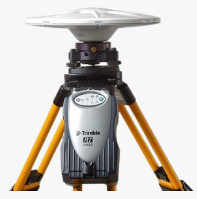
Topographic and geodetic works with GNSS equipment of the Trimble R7 series
One of the indispensable devices for the project of topographic and geodetic works is a high-precision dual-frequency GNSS receiver.
- allows to abandon the use of theodolite and leveling moves;
- allows to carry out a planned high-altitude geodetic reference;
- using it, it is possible create a reference justification along the trace.
GNSS equipment helps to carry out breakdown, field tracing with high accuracy and in real time. Consequently, the process accelerates, the quality and productivity of work increases.
Deformation monitoring by digital levels
Monitoring and keeping track of deformations of objects (subsidence, roll, shifts) is an important task, especially in the process of construction and operation of structures and buildings.
To solve the problems of deformation monitoring, Zhanazhol Munai Service personnel use digital Trimble DINI 03 and Leica DNA 03 levels. They allow timely detection and prevention of the development of negative and dangerous natural and man-made processes.
It should be distinguished:
geodetic monitoring of subsidence of the foundations of buildings is carried out by means of precision levels
observations of shifts and roll are performed by high-precision robotic electronic total stations
The results obtained allow us to predict the scenarios of events: how the deformation will behave, and what specialized measures can prevent negative and dangerous consequences.
Geodesic equipment is equipped with built-in software that allows carrying out the removal in kind, as well as the breakdown of the main and mounting axes, elevations, slopes.
Zhanazhol Munai Service LLP uses modern software products for the production of processing of topographic and geodetic surveys of total stations, levels, GNSS surveys, laser scanning, as well as for drawing up drawings, maps of various scales, 3D maps.
We work with programs: Trimble Business Centre, Surfer, CREDO, MapInfo, 3D FieldPro, AutoCAD, QGIS, GPSurvey, OpendTect, Trimble Geomatic Office.
Linear and rotary levels are often used at construction sites, which have a long range of research. Optical and optical-laser vertical design devices are added to help them, allowing them to transfer the planned coordinates from one horizon to another.
Geodetic monitoring and control of geometric parameters of buildings under construction, as well as the quality of construction is carried out on the basis of data from executive surveys. They are performed by electronic total stations or three-dimensional laser scanners.
Zhanazhol Munai Service LLP uses modern software products for the production of processing of topographic and geodetic surveys of total stations, levels, GNSS surveys, laser scanning, as well as for drawing up drawings, maps of various scales, 3D maps.
We work with programs: Trimble Business Centre, Surfer, CREDO, MapInfo, 3D FieldPro, AutoCAD, QGIS, GPSurvey, OpendTect, Trimble Geomatic Office.
List of topographic and geodetic services
- obtaining coordinates and heights of geodetic points, as well as materials on previously conducted surveys;
- creation of a geodetic reference network (geo-base) and/or survey justification on the studied area;
- search, detection and topographic and geodetic survey of engineering communications underground;
- engineering and geodetic surveys for design;
- preparation/updating of a topographic plan/geo-base.
Received materials and information are processed: data of geodetic and topographic studies are applied to maps. Further, accuracy of these data is determined through desk work.

Field stage

Office works
At the office stage, work begins with topographic plans, while digital versions are used. They should be compiled from scratch or updated: enter data that was collected during field topographic and geodetic works. If the information on the existing plans is outdated, it is updated.
Objects of ground and underground communications, as well as objects are entered on the maps. It is often necessary to coordinate these changes with the organizations operating these facilities and communications.

Having completed all the work ordered by the client, the surveyors of Zhanazhol Munai Service prepare and transmit a technical report in electronic and paper form:
- an explanatory note indicating the studies carried out;
- a set of drawings, topoplans, geo-bases at the required scale.
Topographic and geodetic surveys are a mandatory stage of preliminary study of the territory, preceding geophysical exploration (gravity exploration, magnetic exploration, etc.). The information obtained as a result of topogeodesis is used to obtain accurate terrain data for the removal of survey points from the project in kind. Subsequently, these data will be used for secondary processing of geophysical surveys.
- collection, analysis of information about natural, man-made conditions of the area;
- reconnaissance, study of the features of the topography of the relief;
- creation of planned high—altitude geodetic networks - this allows you to determine the coordinates;
- topographic survey of the area at various scales;
- taking out research points in nature, as well as binding, obtaining their exact heights, coordinates;
- search and detection of underground and ground communications;
- creating a set of topographic plans with different scales (1:100, 1:200, 1:500, 1:1000 or any other);
- preparation of a technical report in paper and electronic form.
- technical report with information about the methodology, technology of the conducted research;
- rough sketches of fixed points of the reference geodetic network;
- catalog with coordinates and heights of survey points.
You can order topographic and geodetic works in "Zhanazhol Munai Service" LLP by contacting the phone number listed on the website or through a special request form.
Republic of Kazakhstan, Aktobe, Tauelsizdik ave., 5 k. 1, office 45