


Gravity surveys

The main advantages of Zhanazhol Munai Service LLP in the provision of gravimetric survey services are use of innovative technologies and advanced techniques in gravity exploration.
The Company has an extensive database of modern equipment necessary for the high-quality survey works. This allows to perform accurate measurements efficiently and in the shortest possible time, and also significantly reduces the cost of work.
Mobility, high productivity, along with economy and environmental cleanliness — this is what characterizes the gravity survey method. A wide range of functional capabilities of the method allows it to be used in solving general geological problems of various levels of complexity, as well as in the search for minerals.
High efficiency of the method is due to a simple reason: density inhomogeneities in rocks and soils are reflected differently in the gravitational field of the earth. Such gravitational anomalies can appear only if the rock from which the earth's crust is formed has heterogeneity.
When solving gravimetric problems, the concept of "excess density" is often used. It denotes the difference between the density of the host rocks and the structures that create the anomaly.
Gravimetric exploration is a relatively inexpensive method, and its application makes it possible to allocate the most promising areas for more detailed studies with less economic costs. For this reason, it is much more profitable to conduct this type of research first, and then launch a more detailed method of field geophysics (seismic exploration, electrical exploration) or start exploratory drilling.
The scope of wide application of the method
- Tectonic zoning
- Study of local structures that may contain minerals (HCS and SM)
- Monitoring of the impact on the reservoir layers during the operation of a gas deposit
- Control over the operation of underground gas storage facilities
- Geodynamic monitoring
- Exploration of oil and gas, minerals
- Regional gravity studies
- Geological mapping
How to improve the efficiency of gravity exploration
The study gives the greatest effectiveness in combination with other geophysical exploration methods. An illustrative example is the addition of gravity exploration by aeromagnetic survey and seismic exploration during regional studies.
In the process of searching for anticlinal folds in the sedimentary rock thickness, it is recommended to add seismic data using the reflected wave method. And when searching for ore deposits — to carry out additional magnetic and seismic exploration.
They are used to study individual local structures. Such survey data can be used to calculate the depth of occurrence and geometry of local structures.
The importance of gravity exploration has especially increased in recent decades due to the emergence and development of satellite gradiometry, as well as the improvement of measuring instruments that allow recording small disturbances of gravitational fields.
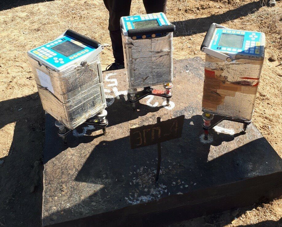
Scintrex CG-5 AugoGrav series of gravimeters is the most accurate and reliable on the modern market. Zhanazhol Munai Service LLP has available high-precision gravimeters Scintrex CG-5 AutoGrav (Canada).
New generation of high-precision gravimeter is an opportunity to develop and test new methods of conducting field gravimetric work. Scintrex CG-5 AutoGrav gravimeter is equipped with the technology of automatic alignment of the device and correction for terrain in real time. Presence of an effective temperature control system allows to achieve high accuracy (about 1 microgal) in a wide temperature range. All this makes it possible to conduct field observations without creating special stationary points (pedestals), but using the "tripod" included in the kit.
|
Operation |
Characteristic |
|
General information |
Scintrex CG-5 AutoGrav gravimeter is a device for high-precision measurement of gravity acceleration. Ensures the accuracy of gravity determination at a point less than 5 microgals. |
|
Required accuracy |
The standard error is + / - 5-7 microGals |
|
Standard deviation |
< 5 microGals |
|
Operating range |
8000 milliGal, without reconfiguration |
|
Residual linear drift |
less than 0.02 milliGal per day |
|
Tilt compensation range |
+/- 200 arc seconds |
|
Automatic correction |
tide, device tilt, temperature, microseisms |
|
Operating temperature |
-40°C to +45°C |
|
Certification |
complies with the European requirements for electromagnetic compatibility 89/336/E |
Very often, the interpretation of gravity survey data is carried out
together with the results of other, parallel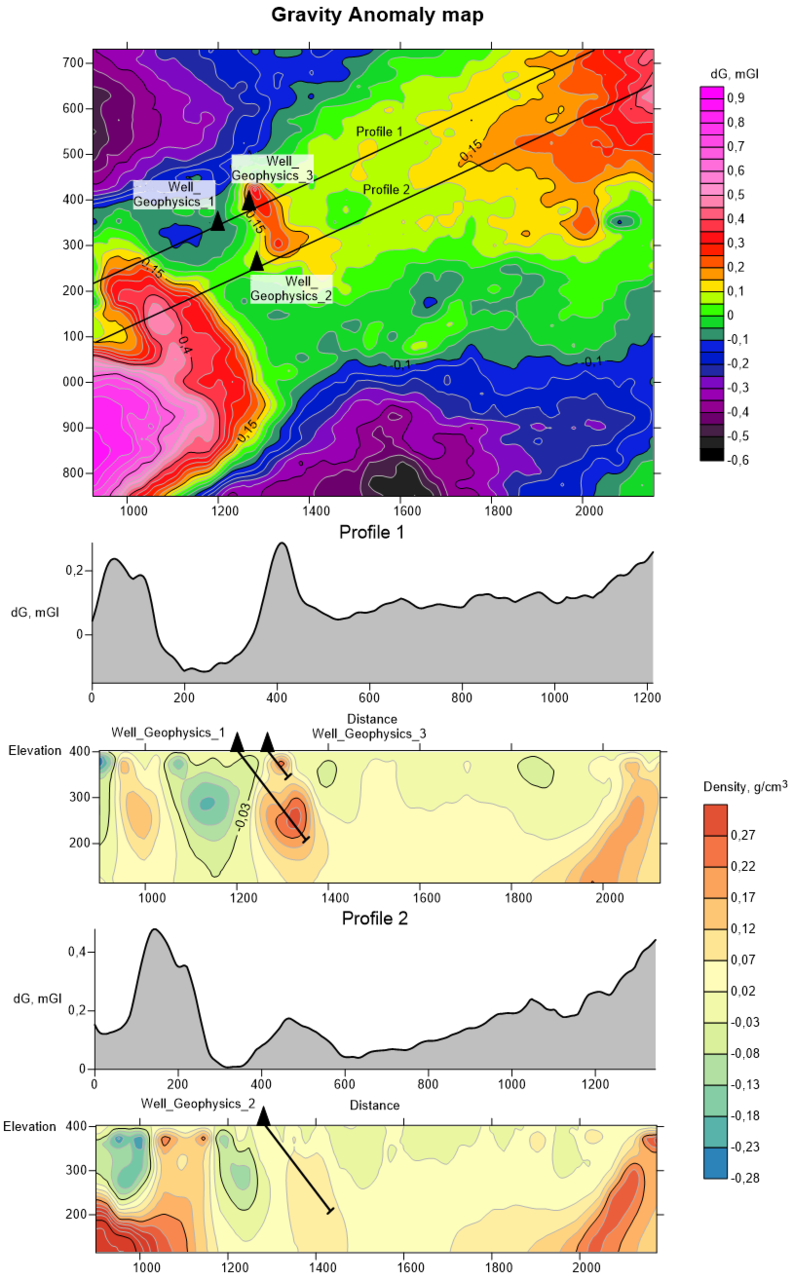 types of surveys: topographic survey, magnetic survey, etc. Interpretation begins with:
- analysis of the received field data;
- primary processing, including the introduction of corrections for the relief and the calculation of the Bouguer anomaly;
- bringing data to a regular observation network.
The next stage of processing is the implementation of transformations of the observed field and the construction of a map of anomalies. It is used at the stage of qualitative interpretation to identify sites promising for the discovery of minerals.
At the final stage, quantitative interpretation and modeling of geological objects that are sources of gravitational anomalies is performed. Gravimetric data processing is performed in the Oasis Montaj, LeapFrog, ZondGM3D software — they allow you to determine the depth of occurrence and spatial position of anomaly-forming objects (gravitational anomalies).
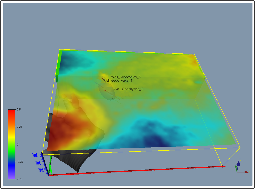
The results of the work are displayed in the form of map of gravity field anomalies, density sections according to interpretive profiles and 3D model of the medium of density inhomogeneities of the exploration site. For the convenience of working with the model, 3D modeling data can be loaded into the OasisMontaj, LeapFrog and other software packages, which allow you to interactively select and analyze the areas of interest.
The results of complex processing and interpretation of gravity survey data make it possible to identify an anomalous zone promising for mineralization.
With the help of 3D inversion of the gravitational field, the parameters (depth, geometry) of areas of increased excess density are determined, which are recommended for testing by drilling for the detection of minerals.
Republic of Kazakhstan, Aktobe, Tauelsizdik ave., 5 k. 1, office 45