


InSAR monitoring

Zhanazhol Munai Service LLP conducts InSAR monitoring of the Earth’s surface (on the territory of oil and gas fields, mines) — performs a full cycle of processing radar satellite images using modern software products. The practice of an integrated approach to data processing, along with the professionalism of employees, gives its results — we can offer various solutions to problems in the field of using space survey materials, namely:
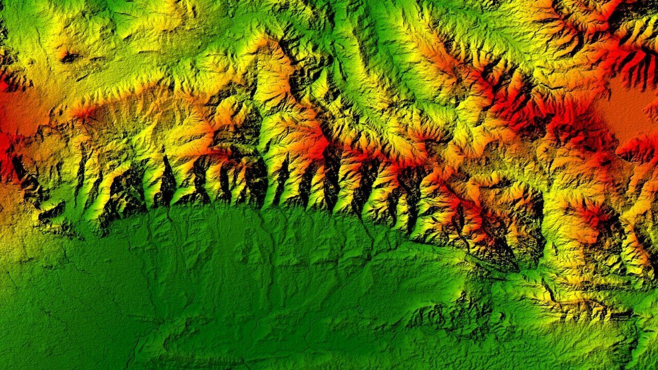
- construction of digital elevation models (DEM);
- monitoring of minimum displacements of the Earth's surface — accuracy up to several millimeters.
Radar space survey is carried out in the ultrashort (ultrahigh frequency) region of radio waves. They are divided into X-, C- and L-ranges. The images are taken via an Earth satellite, or rather, the satellite's onboard equipment (radars).
Creation of digital elevation and land models (DEM)
This is done by means of interferometric processing of the phases of the survey signals. Such information can be used in various areas of society's life. Using radar survey methods and the ability to work without reference to weather conditions, it is possible to map hard-to-reach areas of the planet. At the same time, the process takes place in high spatial resolution — it is now possible to create and update maps to a scale of 1:50 000.
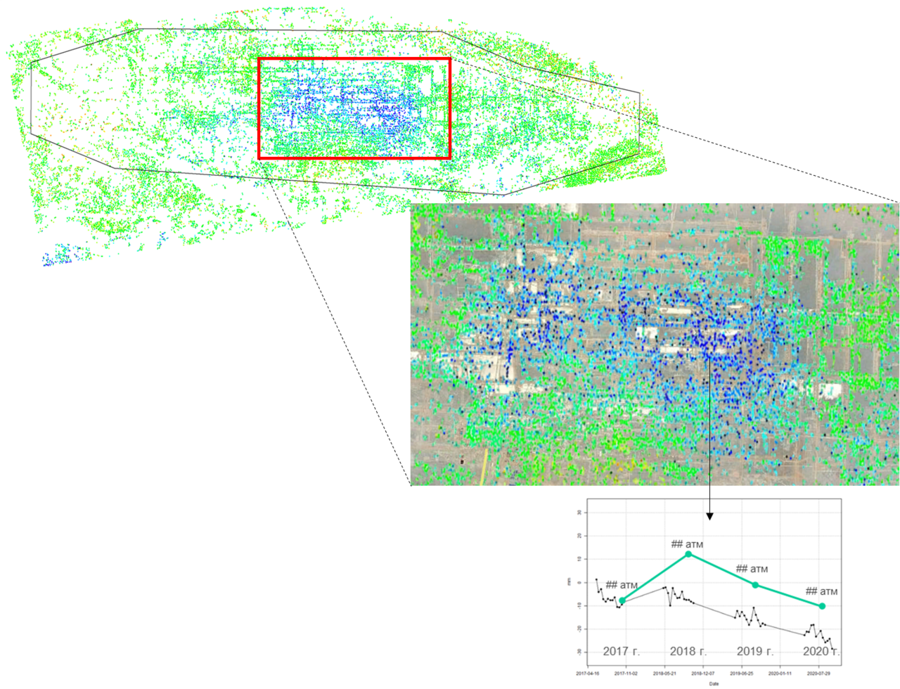
By evaluating multi-time radar images, it is possible to detect:
- subsidence at mineral deposit development sites;
- deviations of infrastructure objects from the normal position with subsequent tracking of landslide processes.
How Radar Interferometry is Performed - The Process of Acquiring Images*:
- the radar beam with electromagnetic pulses is directed at the object;
- the object reflects part of the pulses;
- the sensor measures the received characteristics of the reflected signal, measures the distance to the object.
The process is described in more detail in the article below.
Synthetic Aperture Radars (SAR) or InSAR (from Interferometric Synthetic Aperture Radar) are used in the space satellite radar survey of the Earth. They use Earth remote sensing data from space, which is useful and informative when:
- studying the development of oil and gas fields;
- monitoring or studying subsidence over mines, tunnels;
- monitoring the stability of bridges and overpasses.
The problem of significant subsidences in the consequences — lead to deformations of buildings, structures and infrastructure facilities of deposits. For this reason, it is important to monitor the situation, which will allow:
- to ensure the safety of life;
- to reduce the risks of damage or even loss of infrastructure facilities;
- to support environmental and industrial safety;
- to ensure the protection of the subsurface at the facilities of the oil and gas sector.
Currently, there is a significant grouping of radar Earth sensing satellites in orbit, the data from which does not depend on clouds and illumination. In this regard, they have found wide application in solving the tasks of operational monitoring of subsidence of the Earth caused by the extraction of minerals, oil, gas and water, monitoring of the ice situation, oil spills. The data is obtained with guaranteed frequency.
The principle of operation of Interferometric Synthetic Aperture Radar
The radar device emits electromagnetic pulses in radio and microwave mode and detects reflections of these pulses from objects in the line of sight. The radiation transmitted by the radar reaches the scatterers on the ground and then returns to the radar to form a synthetic aperture radar (SAR) image (two-way trip).
After an accurate assessment of the time delay between the transmitted and received echo, it can determine the inclined range — the distance between the position of the sensor in its flight direction (azimuth) and the illuminated targets on the ground.
Measurements of variations in the trajectory of motion depending on the position of the satellite and the capture time allow to create digital terrain models (DTM) and measure millimeter deformations of the terrain surface.
The radar proved valuable because of its ability to work day and night, as well as penetrate clouds and rain, because it uses microwaves.
Satellite radar interferometry uses a pair of satellite images of one part of the earth's surface taken from two close, locally parallel orbits. In this case, both images are taken by the same satellite or its tandem pair.
A complex interferogram can be calculated from two images. This is a two—dimensional matrix, each element of which is equal to the product of the signal of the first image and the complex conjugate signal of the second. Thus, the phase of each element of the complex interferogram is equal to the phase difference of the two images.
What is an interferogram?
It is a contour map of the change in the distance between the Earth's surface and the radar device. These maps:
- provide unsurpassed spatial sampling density, competitive accuracy and useful observation frequency;
- record the movements of the earth's surface and changes in terrain.
Space radar survey is carried out in the X-, C-, S-, L- and P-bands, each of which has its pros and cons. One or more ranges are selected for monitoring, depending on the specific territory and buildings or structures located on the surface. The choice is influenced by the type of terrain and vegetation cover, as well as the expected values of displacements and other factors.
Table 1. Ranges of the radio wave area of the electromagnetic spectrum
|
Range |
Frequencies, GHz |
Wavelengths, cm |
Satellite systems |
|
X |
5.20 – 10.90 |
2.75 – 5.77 |
USGSSLAR, TerraSAR-X, TanDEM-X, Cosmo-SkyMed 1-4, Kompsat-5 |
|
C |
3.9 – 6.2 |
3.8 – 7.6 |
ERS-1,2; ENVISAT-ASAR; RADARSAT-1,2, RISAT, |
|
S |
2 – 4 |
7.5 – 15 |
Almaz, Condor-E |
|
L |
0.39 – 1.55 |
19.3 – 76.9 |
SIR-A-B, JERS, |
|
P |
0.225 – 0.391 |
40.0 – 76.9 |
AIRSAR, BIOMASS |
The input data used for processing by specialized programs are radar images (an interferometric pair or a multi—pass series of images taken in an identical survey geometry).
Processing is a rather complex process that requires the use of specialized software products and the use of algorithms. Personnel must be experienced and qualified to create secondary products of radar space survey. Such personnel are employed in Zhanazhol Munai Service LLP.
A bit of history
The principle of operation of a synthesized aperture radar was discovered in the early 1950s. Since then, there has been rapid development all over the world and today several onboard and space systems are in operation. Advances in technology and digital signal processing have led to the creation of highly flexible systems useful for military and civilian applications.
Compared with traditional geodetic methods, interferometry provides one opportunity that has long remained inaccessible to surveyors – it is a relatively fast and cheap way to monitor the displacements of the Earth's surface over large areas.
Republic of Kazakhstan, Aktobe, Tauelsizdik ave., 5 k. 1, office 45